Guadalupe Mountains National Park, Texas

El Capitan
Indigenous to the area, the Mescalero Apache (The Spanish gave them the name mescalero -mescal maker) were driven out of their home in the Guadalupes in the 1800s and put on reservations.
I’m a bad park enthusiast. I had no idea this park even existed. I thought Texas only had one national park — Big Bend. So there I was camping in my car outside of Carlsbad Caverns National Park when I did a google search for the tallest mountain in Texas (because that’s what I do). To my surprise it was nearby and to my further surprise it was in a national park. And it was just down the road from Carlsbad Caverns. So I quickly had to change my plans and I decided I would try to hike that mountain instead of check out the caves the next day. I mean, I’ve got a spreadsheet of all the states’ highest peaks (I’ve hiked 10 of them) so I just had to. So the next morning I called the park and talked to a ranger about hiking it. I asked if folks are still hiking it and if the weather (wind) would be okay to summit. He said that people still hike it in winter and that the wind would be 15-20mph (sometimes they top out at 85mph). He said that on the summit with the windchill it will be in the upper 30s. I only had two days in the area so I made the call to go for it.
Guadalupe Mountains are located just east of El Paso and encompass the northern area of the Chihuahuan Desert. The area used to be underwater in the Delaware Sea. A reef made up of algae and sponges was formed and closed the sea off from the rest and ended up evaporating and being filled with evaporates like salt. Then when the mountains rose up it exposed the old reef. Parts of the horseshoe shaped reef are exposed and some parts are still buried. I didn’t learn about any of this until after the hike but I was shocked as I always find it interesting to imagine such desert areas once being a sea. The earth is phenomenal.
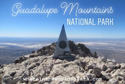
So let me set the scene: blue skies, sunny, high desert filled with prickly pear cactus, agave, ocotillo, and pine trees. It was in the mid 70s at the base. The hike is labeled strenuous and it is about 8.5 miles round trip with about 3000ft gain to the summit at 8749ft.
I got there and paid the $5 entrance fee and started up. I didn’t bring hiking poles on my road trip cause I wasn’t planning on doing any hikes so I decided to just use my ski poles. They worked just fine. Then as I was hiking up I realized this was a bit ambitious for me as I’ve been a couch potato for the past four months and have not been very active, but that’s me, thinking that it wouldn’t be a problem to hike 8 miles being out of shape. I took it slowly and stopped to check out the amazing views. I passed some windy spots where I had to put gloves on from the cold. I realized that I hadn’t put any sunscreen on and that my face was exposed. And eventually I made it to the top. I had been prepared for it to be really cold but it was only in the 50s and I didn’t even need to put a jacket on. I made my way down and the closer to the base the more I felt a blister forming on my toe. I reached the bottom and was pleased that I changed my plans in order to do that hike. It was absolutely worth it. Spectacular views and scenery. Just what I needed.
I left and drove further down the road to check out El Capitan, a prominent rock face jutting out of the desert. And I stopped by to see the ruins of a Butterfield stage coach station. The history of those coaches are impressive. To think that people traveled in that way back in the 1850s is startling.
I woke up the next day with a bad sunburn on my face and super tight calf muscles.
Go check Guadalupe Mountains out if you’re in the area.